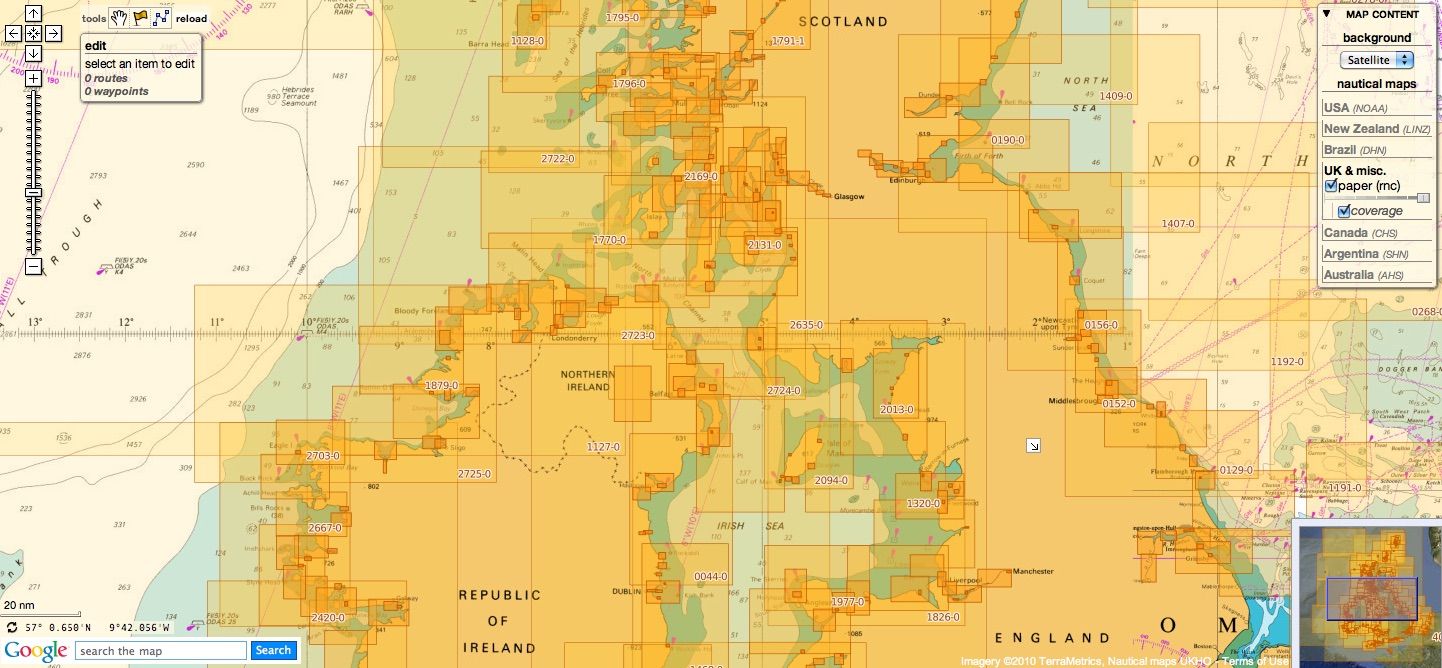
British Isles & miscellaneous other countries update
Today 889 charts (1653 including insets)
are available in the 'British Isles & misc.' chart layer
This product has been derived in part from material obtained from the UK Hydrographic Office with the permission of the UK Hydrographic Office, Her Majesty’s Stationery Office, and the authorities of the following countries : British Isles (UK & Ireland), South Africa & Malta whose national Hydrographic Offices nautical maps are managed by UKHO
see acknowledgements
Note : charts for Portugal and Oman have been withdrawn for this update.
see new layer for Portugal based on ENC rasterized IHPT material
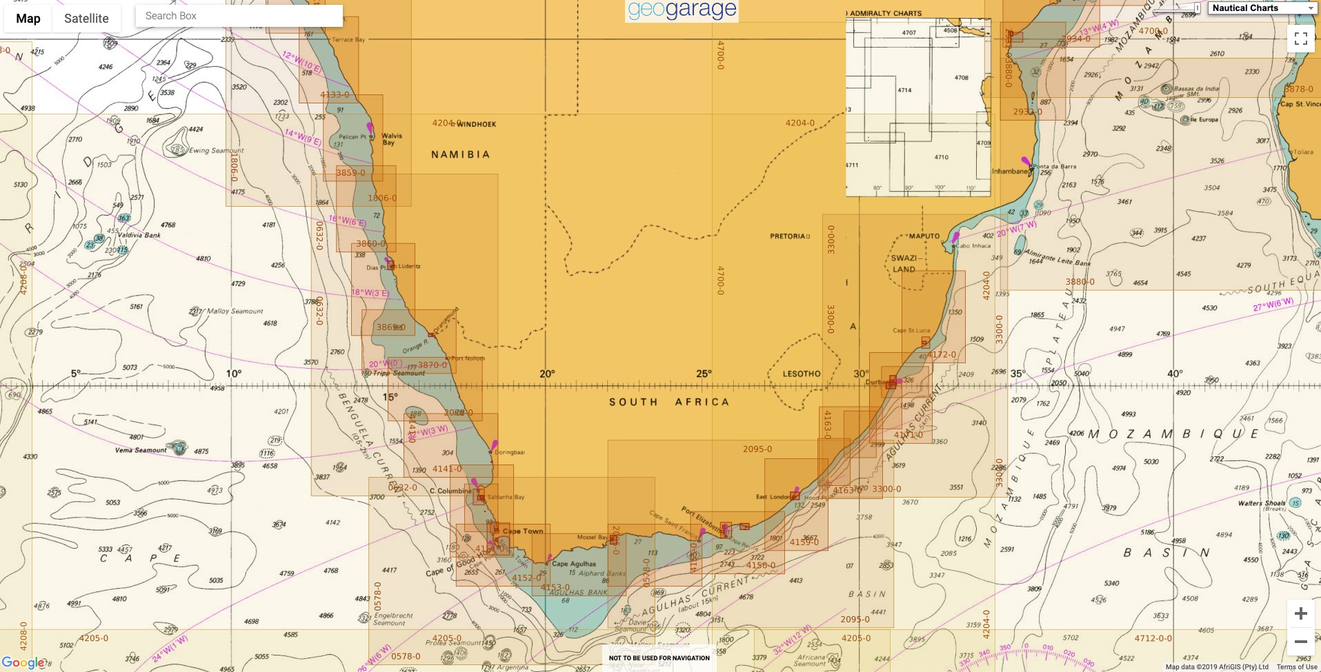
South Africa
55 charts
- 310 Ponta Grossa to Kuene River
- 643 Durban Harbour
- 665 Approaches to Zanzibar
- 1236 Saldanha Bay
- 1846 Table Bay Docks and Approaches
- 1922 RSA - Simon's Bay
- 2078 Port Nolloth to Island Point
- 2930 Jesser Point to Boa Paz
- 3211 Zanzibar Harbour
- 3793 Shixini Point to Port S Johns
- 3794 Port S Johns to Port Shepstone
- 3795 Port Shepstone to Cooper Light
- 3797 Green Point to Tongaat Bluff
- 3859 Cape Cross to Conception Bay
- 3860 Mutzel Bay to Spencer Bay
- 3861 Namibia, Approaches to Luderitz
- 3869 Hottentot Point to Chamais Bay
- 3870 Chamais Bay to Port Nolloth
- 4132 Kunene River to Sand Table Hill
- 4133 Sand Table Hill to Cape Cross
- 4136 Harbours on the West Coasts of Namibia and South Africa
- 4137 International Chart Series, Southern Africa - West Coast, Namibia, Walvis Bay Harbour
- 4138 International Chart Series, South Africa - West Coast, Namibia, Approaches to Walvis Bay
- 4141 Island Point to Cape Deseada
- 4142 Saldanha Bay Harbour
- 4145 Approaches to Saldanha Bay
- 4146 Cape Columbine to Table Bay
- 4148 Approaches to Table Bay
- 4150 Republic of South Africa, South West Coast, Table Bay to Valsbaai
- 4151 Cape Deseada to Table Bay
- 4152 Republic of South Africa, South West Coast, Table Bay to Cape Agulhas
- 4153 Republic of South Africa, South Coast, Cape Agulhas to Cape St. Blaize
- 4154 Mossel Bay
- 4155 Cape St Blaize to Cape St Francis
- 4156 South Africa, Cape St Francis to Great Fish Point
- 4157 South Africa, Approaches to Port Elizabeth
- 4158 Republic of South Africa - South Coast, Plans in Algoa Bay.
- 4159 Great Fish Point to Mbashe Point
- 4160 Ngqura Harbour
- 4162 Approaches to East London
- 4163 Republic of South Africa, South East Coast, Mbashe Point to Port Shepstone
- 4169 Republic of South Africa - East Coast, Approaches to Durban Oil Terminal SBM
- 4170 Approaches to Durban
- 4171 Republic of South Africa – South East Coast, Port Shepstone to Tugela River.
- 4172 Tugela River to Ponta do Ouro
- 4173 Approaches to Richards Bay
- 4174 Richards Bay Harbour
- 4175 International Chart Series, Angola and Namibia, Baia Dos Tigres to Walvis Bay
-
4176 International Chart Series, Namibia and South Africa, Walvis Bay to Orange River
-
4177 International Chart Series, Namibia and South Africa, Orange River to Table Bay
-
4178 International Chart Series, Republic of South Africa - South Coast,Table Bay to East London
-
4179 International Chart Series, Republic of South Africa - East Coast ,East London to Richards Bay
- 4180 International Chart Series, Republic of South Africa and Mozambique, Richards Bay to Inhambane
- 4204 International Chart Series, South Atlantic and Indian Oceans, Walvis Bay to Maputo
- 4205 Agulhas Plateau to Discovery Seamounts
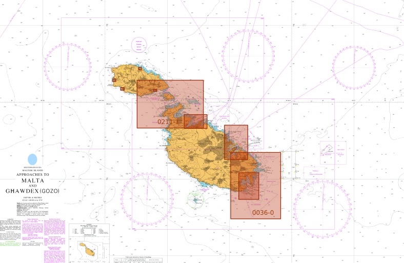
Malta
5 charts
- 36 Marsaxlokk
- 177 Valletta Harbours
- 211 Plans in the Maltese Islands
- 2537 Ghawdex (Gozo), Kemmuna (Comino) and the Northern Part of Malta
- 2538 Malta
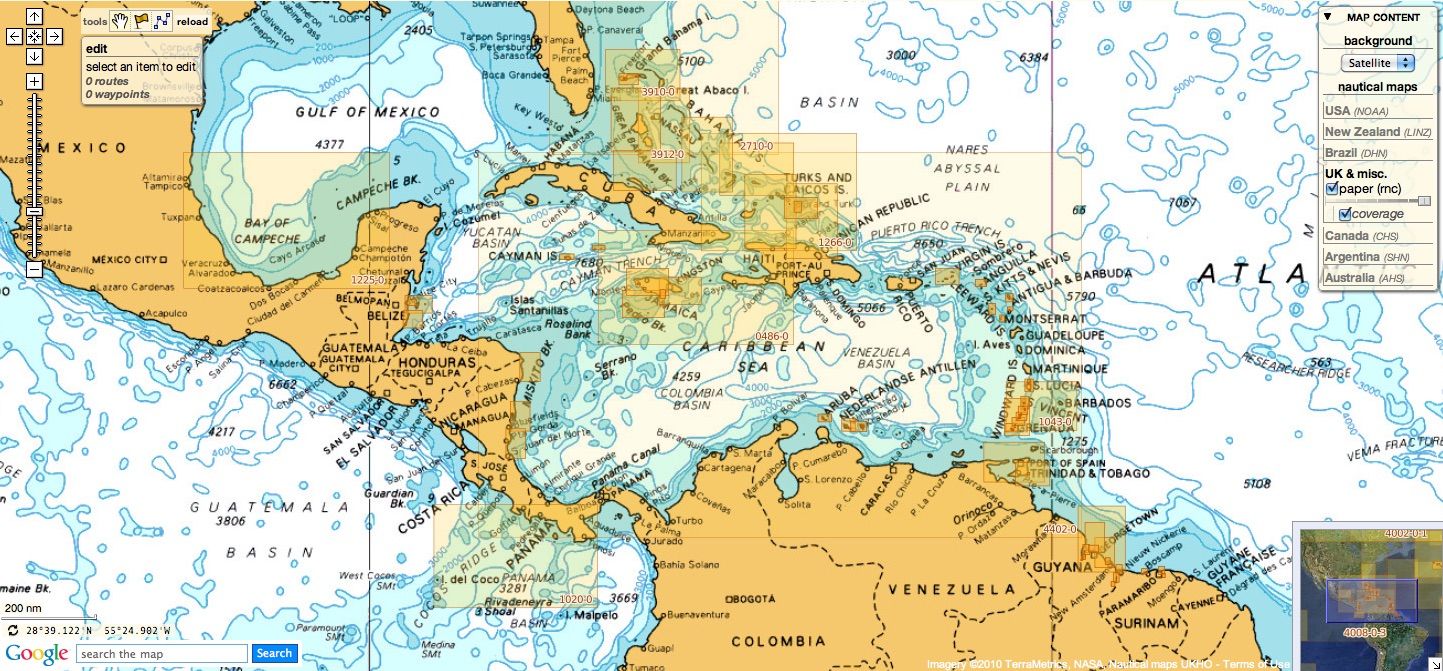
NGA
41 international charts
- 3 International Chart Series, Indian Ocean, British Indian Ocean Territory, Chagos Archipelago
- 82 Outer Approaches to Port Sudan
- 100 International Chart Series, Africa - East Coast, Gees Gwardafuy (Raas Caseyr) to Suqutra (Socotra)
- 255 Eastern Approaches to Jamaica
- 256 Western Approaches to Jamaica
- 260 Pedro Bank to the South Coast of Jamaica
- 333 Offshore Installations in the Gulf of Suez
- 334 North Atlantic Ocean, Bermuda
- 386 Yadua Island to Yaqaga Island
- 390 Bahamas, Grand Bahama Island, Approaches to Freeport
- 398 Bahamas - Grand Bahama Island, Freeport Roads
- 447 International Chart Series, Antarctica - Graham Land, Pendleton Strait and Grandidier Channel
- 462 West Indies, The Cayman Islands
- 501 South East Approaches to Trinidad
- 920 Chagos Archipelago, Diego Garcia
- 1043 Saint Lucia to Grenada and Barbados
- 1265 Approaches to Shatt Al 'Arab or Arvand Rud, Khawr Al Amaya and Khawr Al Kafka
- 1450 Turks and Caicos Islands, Turks Island Passage and Mouchoir Passage
- 2133 International Chart Series, Red Sea - Egypt, Gulf of Suez, Approaches to Suez Bay (Bahr Al Qulzum)
- 2373 International Chart Series, Red Sea - Egypt, Gulf of Suez, Suez Bay (Bahr el Qulzum) to Ra's Sharatib
- 2374 International Chart Series, Red Sea - Egypt, Gulf of Suez, Ra's Sharatib to Juzur Ashrafi
- 2658 International Chart Series, Red Sea, Saudi Arabia, Outer Approaches to Jeddah (Mina` al Jiddah)
- 2837 Strait of Hormuz to Qatar
- 2975 International Chart Series, Antarctica - Graham Land, Matha Strait to Larrouy Island
- 3175 International Chart Series, United Arab Emirates and Iran, Jazirat al Hamra' to Dubai (Dubayy) and Jazireh-Ye Sirri
- 3310 International Chart Series, Africa - East Coast, Mafia Island to Pemba Island
- 3361 International Chart Series, Kenya and Tanzania, Pemba Island to Lamu [Previously titled: Wasin Island to Malindi]
- 3493 Red Sea - Sudan, Bashayer Oil Terminals and Approaches.
- 3519 Arabian Sea, Oman, Southern Approaches to Masirah
- 3522 Oman, Approaches to Muscat (Masqat) and Mina' al Fahl
- 3530 Gulf of Aden, Somalia, Approaches to Berbera
-
3572 International Chart Series, Antarctica - Graham Land, Brabant Island to Adelaide Island
-
3579 International Chart Series, Antarctica, Rydberg Peninsula to Siple Island
- 3723 Gulf of Oman, United Arab Emirates, Approaches to Khawr Fakkan and Fujairah (Fujayrah).
- 3785 Arabia, Oman - South East Coast, Port Salalah (Mina' Raysut) to Masirah (Al Masirah)
- 3907 International Chart Series, Bahama Islands and Hispaniola, Passages between Mayaguana Island and Turks and Caicos Islands including Northern Approaches to Haiti and Dominican Republic
- 3908 International Chart Series, West Indies, Passages between Turks and Caicos Islands and Dominican Republic
- 3910 Little Bahama Bank including North West Providence Channel
- 3912 Bahamas, North East Providence Channel and Tongue of the Ocean
- 3913 Bahamas, Crooked Island Passage and Exuma Sound
- 3914 Turks and Caicos Islands and Bahamas - Caicos Passage and Mayaguana Passage
These updates are automatically viewable on mobile applications :
- Weather 4D R&N iPhone-iPad iOS9+ on the Apple Store with subscriptions available on GeoGarage platform online payment website
- SailGrib Android on the Google Store with subscriptions available on GeoGarage platform online payment website
Don't forget to visit the UKHO Notices to Mariners : NTM for 2024